<?xml version="1.0" encoding="utf-8"?>
<feed xmlns="http://www.w3.org/2005/Atom">
	<title type="html"><![CDATA[Infinity Code Forum — About elevations resolution]]></title>
	<link rel="self" href="https://forum.infinity-code.com/extern.php?action=feed&amp;tid=1664&amp;type=atom" />
	<updated>2020-12-14T18:04:54Z</updated>
	<generator>PunBB</generator>
	<id>https://forum.infinity-code.com/viewtopic.php?id=1664</id>
		<entry>
			<title type="html"><![CDATA[Re: About elevations resolution]]></title>
			<link rel="alternate" href="https://forum.infinity-code.com/viewtopic.php?pid=7006#p7006" />
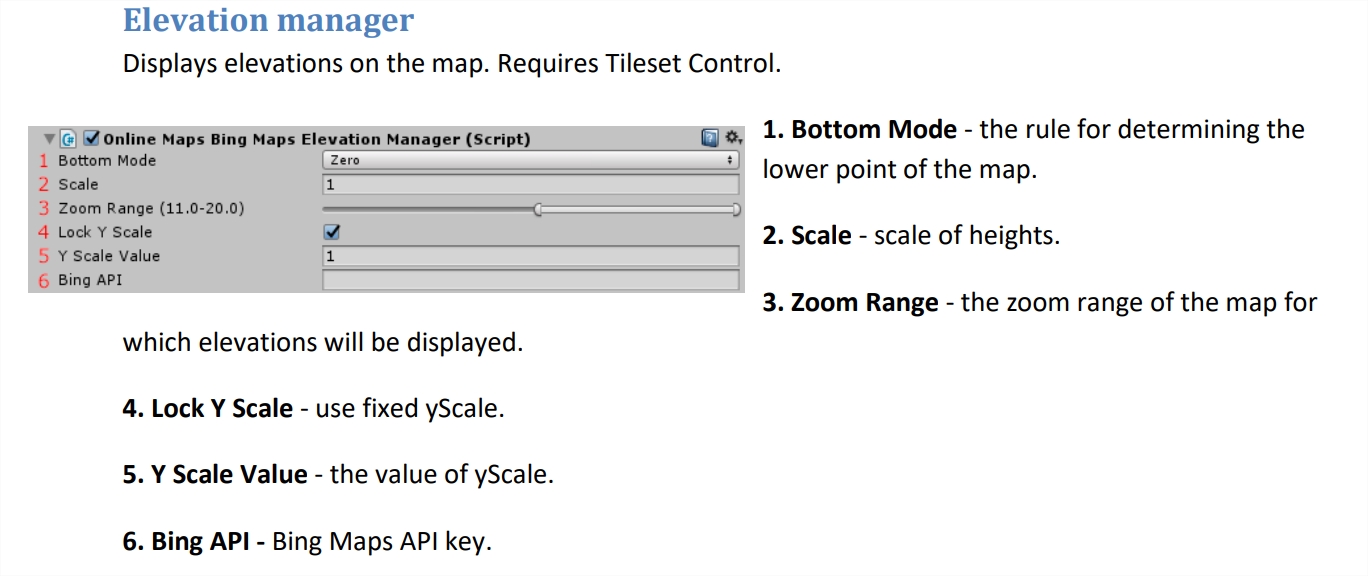
			<content type="html"><![CDATA[<p>In the latest versions of the Unity Editor, if a component has an item in the menu, then via Add Component this component will also have the same name as in the menu.<br />In some cases (like this one) this is quite inconvenient, but I don&#039;t know of a way to fix it.</p><p>These components are called:<br />Bing Maps - OnlineMapsBingMapsElevationManager.<br />Bing Maps Tiled - OnlineMapsBingMapsTiledElevationManager.<br />Mapbox - OnlineMapsMapboxElevationManager.</p><p>Or you can find these scripts in the project and just drag and drop onto the GameObject,</p><p>Geoportail elevation data can only be used through Online Maps API.</p>]]></content>
			<author>
				<name><![CDATA[Alex Vertax]]></name>
				<uri>https://forum.infinity-code.com/profile.php?id=2</uri>
			</author>
			<updated>2020-12-14T18:04:54Z</updated>
			<id>https://forum.infinity-code.com/viewtopic.php?pid=7006#p7006</id>
		</entry>
		<entry>
			<title type="html"><![CDATA[Re: About elevations resolution]]></title>
			<link rel="alternate" href="https://forum.infinity-code.com/viewtopic.php?pid=7005#p7005" />
			<content type="html"><![CDATA[<div class="quotebox"><cite>Alex Vertax wrote:</cite><blockquote><p>Bing Maps has good data quality for this location, and you can use Bing Maps instead of ArcGIS.<br />Mapbox probably has good data quality too, but this service is temporarily unavailable right now and I cannot check it.</p></blockquote></div><p>Thanks but as I wrote in my 1st post, I don&#039;t see any script using Bing ?</p><p><span class="postimg"><img src="https://zooomez.fr/ph/images/bing.jpg" alt="PCompare" /></span></p><p>The only script with &quot;Bing&quot; is &quot;BingMapsElavationExample&quot; I added it but it seems it doesn&#039;t change anything? <br />Where is the OnlineMapsBingMapsElevationManager.cs script ?</p><p>Which script to use MapBox Elevations ?<br />Any way to get Geoportail elevation data ?</p><p>Best regards</p>]]></content>
			<author>
				<name><![CDATA[philzmz]]></name>
				<uri>https://forum.infinity-code.com/profile.php?id=606</uri>
			</author>
			<updated>2020-12-14T17:53:34Z</updated>
			<id>https://forum.infinity-code.com/viewtopic.php?pid=7005#p7005</id>
		</entry>
		<entry>
			<title type="html"><![CDATA[Re: About elevations resolution]]></title>
			<link rel="alternate" href="https://forum.infinity-code.com/viewtopic.php?pid=7004#p7004" />
			<content type="html"><![CDATA[<p>I checked your place, and:<br />Different sources have different data quality for different locations.<br />This applies to tiles and elevation data.<br />In this particular case, ArcGIS has low quality elevation data for this location.<br />You or I cannot fix this.<br />Bing Maps has good data quality for this location, and you can use Bing Maps instead of ArcGIS.<br />Mapbox probably has good data quality too, but this service is temporarily unavailable right now and I cannot check it.</p>]]></content>
			<author>
				<name><![CDATA[Alex Vertax]]></name>
				<uri>https://forum.infinity-code.com/profile.php?id=2</uri>
			</author>
			<updated>2020-12-14T14:12:10Z</updated>
			<id>https://forum.infinity-code.com/viewtopic.php?pid=7004#p7004</id>
		</entry>
		<entry>
			<title type="html"><![CDATA[Re: About elevations resolution]]></title>
			<link rel="alternate" href="https://forum.infinity-code.com/viewtopic.php?pid=7003#p7003" />
			<content type="html"><![CDATA[<div class="quotebox"><cite>Alex Vertax wrote:</cite><blockquote><p>Hello.</p><p>Please show the coordinates of this place.</p></blockquote></div><p>Yes of course...</p><p>43.91045092495649, 3.7363208717925396</p><p><a href="https://www.google.fr/maps/@43.9076434,3.7353536,482a,35y,39.31t/data=!3m1!1e3">https://www.google.fr/maps/@43.9076434, … a=!3m1!1e3</a></p>]]></content>
			<author>
				<name><![CDATA[philzmz]]></name>
				<uri>https://forum.infinity-code.com/profile.php?id=606</uri>
			</author>
			<updated>2020-12-14T09:27:12Z</updated>
			<id>https://forum.infinity-code.com/viewtopic.php?pid=7003#p7003</id>
		</entry>
		<entry>
			<title type="html"><![CDATA[Re: About elevations resolution]]></title>
			<link rel="alternate" href="https://forum.infinity-code.com/viewtopic.php?pid=7001#p7001" />
			<content type="html"><![CDATA[<p>Hello.</p><p>Please show the coordinates of this place.</p>]]></content>
			<author>
				<name><![CDATA[Alex Vertax]]></name>
				<uri>https://forum.infinity-code.com/profile.php?id=2</uri>
			</author>
			<updated>2020-12-13T18:48:21Z</updated>
			<id>https://forum.infinity-code.com/viewtopic.php?pid=7001#p7001</id>
		</entry>
		<entry>
			<title type="html"><![CDATA[About elevations resolution]]></title>
			<link rel="alternate" href="https://forum.infinity-code.com/viewtopic.php?pid=7000#p7000" />
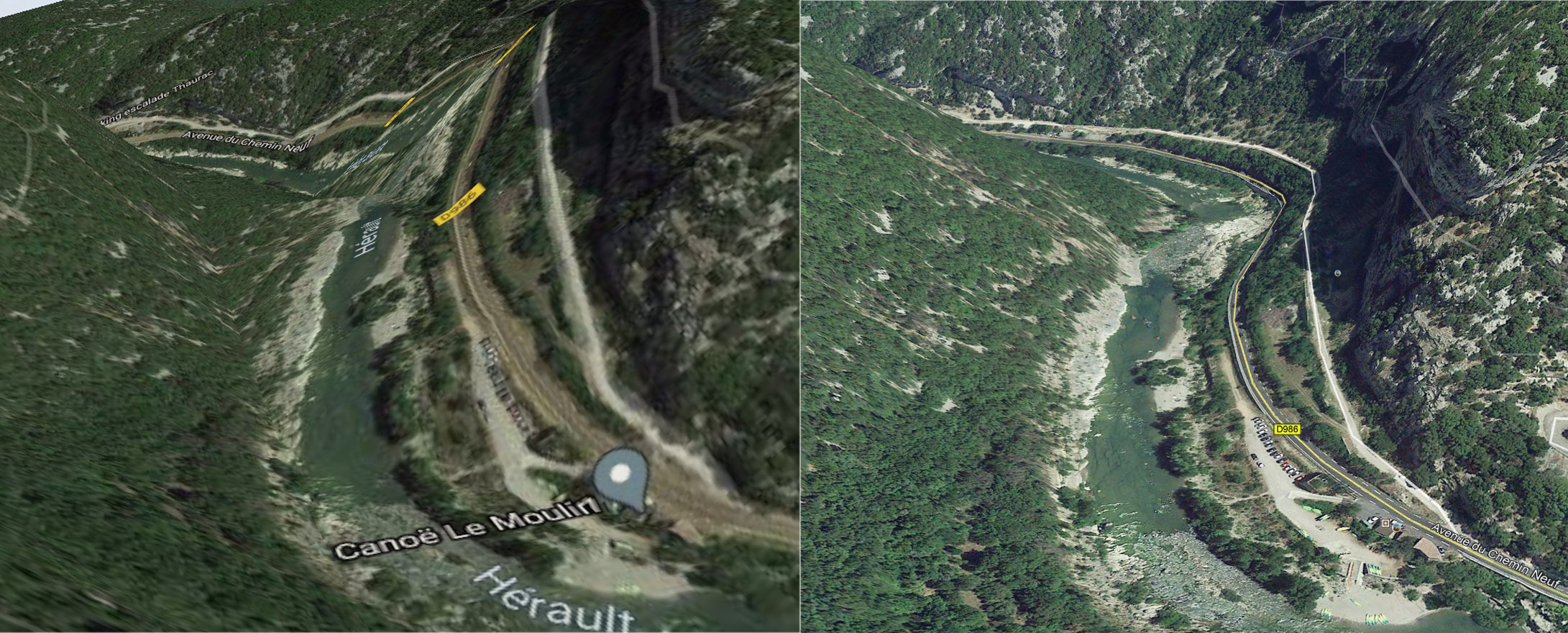
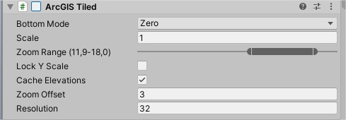
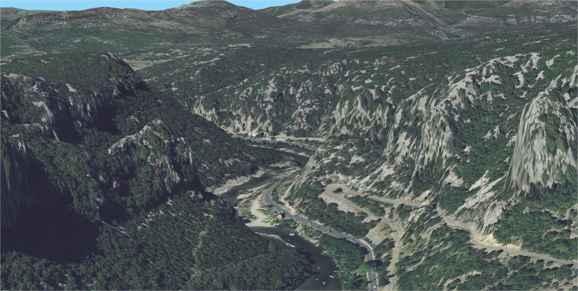
			<content type="html"><![CDATA[<p>Hello<br />On this screen capture<br /><span class="postimg"><img src="https://zooomez.fr/ph/images/compareGEarth-OLMaps.jpg" alt="PCompare" /></span><br />- On the left, the aspect that I get with OLMaps<br />- On the right, about the same location on Google Earth, which is much more accurate, the road doesn&#039;t climb on the cliff...<br />Same texture on both images, provided by Google Maps. <br />My Arcgis parameters are</p><p><span class="postimg"><img src="https://zooomez.fr/ph/images/Arcgis.jpg" alt="PCompare" /></span></p><p>Changing the resolution (Min = 16 - Max = 100) doesn&#039;t change anything.<br />In the documentation the elevation seems to be managed by bing, but there is no such script ?<br /><span class="postimg"><img src="https://zooomez.fr/ph/images/bing.jpg" alt="PCompare" /></span><br />Which is the better way to get the GoogleEarth (or even better) elevation accuracy ?<br />Geoportail has a good elevation accuracy too, but the 3D mode is very very slow... And I don&#039;t know how I can get the elevation data, maybe there is something to do ?</p><p><span class="postimg"><img src="https://zooomez.fr/ph/images/geoportail.jpg" alt="PCompare" /></span></p><br /><p>Best regards.</p>]]></content>
			<author>
				<name><![CDATA[philzmz]]></name>
				<uri>https://forum.infinity-code.com/profile.php?id=606</uri>
			</author>
			<updated>2020-12-13T18:11:03Z</updated>
			<id>https://forum.infinity-code.com/viewtopic.php?pid=7000#p7000</id>
		</entry>
</feed>